
Mid-frequency active (MFA) sonar pings were detected this morning (Monday, 2/6/12) on the Salish Sea Hydrophone Network by Jeanne Hyde and signal processing computers. Utilizing online ship tracking data from the Automatic Identification System, Jeanne found the Canadian Naval vessel HMCS Ottawa (MMSI 316195000) entering Haro Strait as she continued to hear “pings” from its SQS 510 (V) mid-frequency active sonar on the live hydrophone located at Lime Kiln State Park. Her experience is detailed on her blog, Whale of a Porpoise.
Here’s an example of what she heard: a single ping from the SQS 510 sonar.
Jeanne’s recording (below) begins at 04:49 and ends at 05:39. 82 pings occur in the first 38.25 minutes of the recording, resulting in an average ping rate of 1 ping every 28.35 seconds. Extrapolating back to the first automated detection of a ping (at Lime Kiln) at 04:42:50, there were likely at least 14 pings emitted before Jeanne started recording. So, the minimum total number of pings emitted is 96.
41-minute recording of 82 pings (15 Mb mp3 file) by Jeanne Hyde from the Lime Kiln live hydrophone stream
This is the first detection of Canadian MFA sonar on our hydrophone network, and — to our knowledge — the first time Canadian sonar has been used in the U.S. critical habitat of the Southern Resident killer whales, an iconic marine mammal population that is listed as endangered on both sides of the border. While policies guiding Canadian Naval use of mid-frequency sonar in U.S. critical habitat are not clear to us, there is guidance on the web regarding Canadian use of Canadian Low Frequency Active (LFA) Sonar (at least in the Atlantic).

As a start to evaluating the potential acoustic impacts of this incident, we report here on the preliminary hydrophone and vessel location data collected by the Network during this incident, including: human detections and recordings; automated detections and recordings; and AIS data logged at the Lime Kiln. We are also aggregating information from regional sighting and listening networks about species that may have been ensonified. As additional data and analyses become available, updates will be posted here. Authors of this analysis are bioacoustians: Jason Wood, Research Associate with The Whale Museum; and Scott Veirs, of Beam Reach Marine Science and Sustainability School.
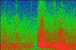
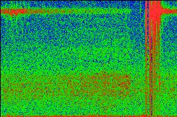
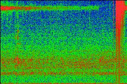
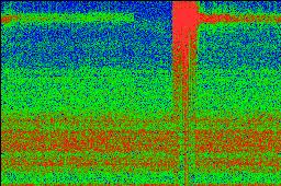
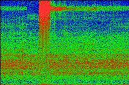
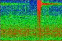
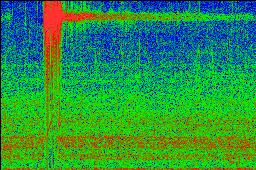
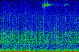
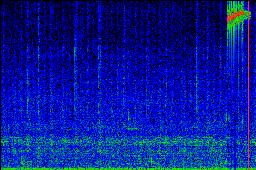
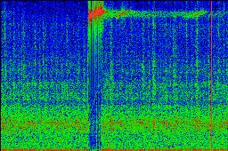
Below are the compressed (mp3) recordings and coarse spectrograms of the sounds that were auto-detected this morning. They begin with a series of low frequency sounds and echoes that may have been from an impulsive source, like a detonation or explosion. Then the series of high-frequency pings occurs between 4:42:50 and 5:08:17 at three network locations: Lime Kiln (13 pings), Port Townsend (1), and Orcasound (1). While we are not yet sure if pings were detected at Neah Bay or on the NEPTUNE Canada hydrophones located near the entrance to the Strait of Juan de Fuca, it appears that the sonar ensonified a good portion of the eastern Strait of Juan de Fuca and southern Haro Strait.
First there were 4 detections of explosive sounds (3/12/2012 update: 5 detections)
Note of clarification added on 2/9/12 at 13:30: In the following table of audio recording files and spectrogram images, the “node” or hydrophone location is denoted with “lk” meaning Lime Kiln State Park, “os” meaning Orcasound (5 km north of Lime Kiln), and “pt” meaning Port Townsend Marine Science Center. The “dB” label offers an estimate of the 30-second average (RMS) received sound pressure level at the time the recording was triggered, and therefore should not be taken as an indication of the receive level of any particular sound heard within the recording (i.e. an explosion or sonar ping) The trigger label indicates whether the sound was recorded because it was exceptionally loud (“PWR”) or because it had the changing pitch and duration typical of a killer whale call (“PKT”).
3/12/2012 update — 1 Detection at Orcasound (~5km north of Lime Kiln)
 2012-02-06 04:31:05 node=os dB=107 trigger=PWR |
|---|
3/12/2012 update — The Lime Kiln recordings were made from a single Reson TC4032 (on both channels in the stereo recordings). The single detection at Orcasound does not match the arrival times of auto-detected explosive-sounds at Lime Kiln within the few seconds that would warrant estimation of the bearing to the source (or at least suggest whether the source was north or south of the hydrophones. The only explanation for the distinct arrival times are: (1) the sound source was too faint to be detected at both locations; (2) the computer clocks were not synchronized to NIST (though software was installed to do so at all hydrophone network locations); or (3) (more likely) something caused the longer-term mean receive level to rise at LK or OS to the point that the PWR trigger threshold was exceeded only at the quieter location when a given explosive-like sound arrived.
 2012-02-06 04:32:37 node=lk dB=102 trigger=PWR |
 2012-02-06 04:33:08 node=lk dB=103 trigger=PWR |
|---|---|
 2012-02-06 04:38:35 node=lk dB=103 trigger=PWR |
 2012-02-06 04:39:07 node=lk dB=104 trigger=PWR |
Then there were 14 detections of sonar pings
Note of clarification added on 2/9/12 at 13:30: In the following table of audio recording files and spectrogram images, the “node” or hydrophone location is denoted with “lk” meaning Lime Kiln State Park, “os” meaning Orcasound (5 km north of Lime Kiln), and “pt” meaning Port Townsend Marine Science Center. The “dB” label offers an estimate of the 30-second average (RMS) received sound pressure level at the time the recording was triggered, and therefore should not be taken as an indication of the receive level of any particular sound heard within the recording (i.e. an explosion or sonar ping) The trigger label indicates whether the sound was recorded because it was exceptionally loud (“PWR”) or because it had the changing pitch and duration typical of a killer whale call (“PKT”).
 2012-02-06 04:42:50 node=lk dB=118 trigger=PWR |
 2012-02-06 04:43:44 node=lk dB=121 trigger=PWR |
|---|---|
 2012-02-06 04:44:12 node=lk dB=120 trigger=PWR |
False positive deleted… |
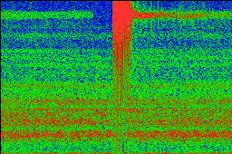 2012-02-06 04:44:41 node=lk dB=118 trigger=PWR |
 2012-02-06 04:45:35 node=lk dB=121 trigger=PWR |
 2012-02-06 04:46:32 node=lk dB=120 trigger=PWR |
 2012-02-06 04:47:00 node=lk dB=121 trigger=PWR |
 2012-02-06 04:48:01 node=pt dB=91 trigger=PKT |
 2012-02-06 04:48:52 2012-02-06 04:48:52node=lk dB=119 trigger=PWR |
 2012-02-06 04:49:22 node=lk dB=120 trigger=PWR |
 2012-02-06 04:57:50 node=os dB=126 trigger=PKT |
 2012-02-06 04:57:55 node=lk dB=106 trigger=PKT |
 2012-02-06 05:05:56 node=lk dB=114 trigger=PKT |
 2012-02-06 05:08:17 node=lk dB=115 trigger=PKT |
While it is possible that other vessels were involved in the sounds recorded this morning, the location and public description of the Ottawa are consistent with what was heard. We are particularly curious about the source of the explosive sounds heard before the sonar pings.
According to hazegray.org, the Ottawa is a multi-role patrol frigate (FFH [Cardinal Mark N; Eog BEOFOR, “Ocean Beaver”?]) Halifax class vessel, 134 m long and X 16 m wide, displacing 4,470 metric tons, with maximum speed of 29+ knots and a compliment of 225 sailors. It carries two sonar systems: the hull-mounted mid-frequency SQS-510 and the low-frequency SQR-19(V) w/CANTASS towed array.
AIS systems report that it was last in port in San Diego, has been operating in the north Pacific, and was bound for Esquimalt mid-morning today. The “show track” feature of marinetraffic.com revealed mid-day today this track from 21:15 2/5/12 through 08:52 this morning (2/6/12).


A rough chronology from combining acoustic detections and AIS data (Google spreadsheet embedded below) suggests the following sequence of events. After steaming through the night through the Strait of Juan de Fuca, the Ottawa slowed down near Race Rocks and turned into the waters south of Victoria. It then reacted — possibly to detonation-like sounds that were auto-recorded at Lime Kiln — and then changed speed and course, began pinging, crossed into U.S. waters, turned northward at near maximum speed, stopped pinging and slowed down as it crossed over Middle Bank, proceeded further north, and then turned back to return to the Canadian waters south of it’s home port of Esquimalt.

A 50 millisecond sample of the starting frequencies of an example ping had peak power at 7042 Hz with a secondary peaks at 1523 Hz, 12615 Hz, and 21171 Hz (see figure below from Audacity). The peak power frequency is consistent with the 2-8 kHz frequency range specified for the SQS 510 sonar system, which is manufactured by General Dynamics Canada. Each ping had high intensity receive levels for ~0.5 second duration and pings were separated by about one minute.

Further details regarding the expected source and receive levels from the SQS 510 can be derived from its 1997 description in the book “The Naval Institute guide to world naval weapons systems, 1997-1998.” While it is likely that the system has been up-dated since 1997, this general description provides helpful characteristics:
SQS-505/509510/Type 5051
SQS-505 is the standard Canadian surface-ship sonar. Its 36 stave [10 elements/stave] cylindrical transducer (4ft dia x 4 ft) produces 35 10×10-deg beams at 6.4, 7.2, or 8.0 kHz [bandwidth 400 Hz divided into sixteen 25-Hz channels for each beam]. Modes: ODT, triple RDT (TRDT), directional transmission (DT), ASPECT, and swept FM (wide-band mode). Pulse lengths: 2.5, 10, 40, 480 msec. Source level: 126 dB (ODT), 135 dB (TRDT, DT). Signal processing: matched filter with time, function automatic gain control (TFAGC) or incoherent (wide-band) processing. Nominal range is 200-32,000 yd (range scales 2, 4, 8, 16, 32 kyd). Target Doppler can be up to 40 kt. Passive operation: 10 kHz. Track capacity is five targets.
….
The (V)6 version for the “City” class has new transmitter and receiver (source level 133 dB, pulse length 10 or 40 msec). Active frequencies match those of earlier versions, but passive frequency is reduced to 4.5 kHz and there is a steerable passive mode.
….
Our next steps are to estimate calibrated receive levels during the event and to gather more information about animals that may have been exposed to harmful sound levels. We may also attempt to estimate the approximate location of the explosive sounds.
In the interim, please report any observations of injured or stranded marine mammals in U.S. waters to NOAA by calling their hotline: 1-800-853-1964. Report unusual behavior or strandings in Candian waters to DFO by calling their hotline: 1-800-465-4336.
It appears there are some Naval exercises going on Feb 5-18, 2012 in the Pacific that include other Canadian vessels and may involve scenarios related to “marine mammal sightings”:
http://www.navy.forces.gc.ca/marpac/4/4-w_eng.asp?id=1163
Deborah Simpson, a marine naturalist from Vancouver, BC, received this explanation from the Canadian Navy on Monday (2/6/12):
An initial synopsis from the AP:
http://www.kndo.com/story/16699707/hydrophones-pick-up-sonar-pings-in-wa-waters
The Canadian navy safety zone for the 510 sonar is 4000 yards
Thanks, Dom. Perhaps they can scan that radius from the bridge with the right tools at night? And does the zone change when operating in the U.S., I wonder?
Also, our automated detectors have revealed that the endangered Southern Resident killer whales were indeed in the neighborhood, but 18 hours after the sonar event.
http://www.orcasound.net/wp/2012/02/08/endangered-orcas-in-haro-strait-18-hours-after-sonar-use/
Here are some links to articles with further information and implications:
NRDC blog by Michael Jasny —
http://switchboard.nrdc.org/blogs/mjasny/canada_uses_dangerous_sonar_in.html
Actually — we may have not recorded some of the initial pings and so may not be able to assess whether or not the sonar use included the ramp up procedures called for in the Canadian Navy’s Marine Mammal Mitigation Measures.
Seattle Times article by Craig Welch —
http://seattletimes.nwsource.com/html/localnews/2017460670_sonar09m.html
We will re-examine the timing of our recordings and the AIS logs to assess the validity of this quote: “The frigate was in Canadian waters at the time, said Lt. Diane Larose of the Canadian navy.” The time stamps on our recordings are synced continuously with NIST clocks thanks to our computers being connected to the Internet, but our initial analysis relied on publicly available archived AIS data (from marinetraffic.com). It may be possible that the time transmitted by the Ottawa AIS system was off or was corrupted en route to the marinetraffic.com web site, but that would be pretty surprising.
A few more articles based on Associated Press information:
Seattle Times note from Wed 2/8/12 at 15:20 —
http://seattletimes.nwsource.com/html/localnews/2017459817_apwanavysonar.html
Komo News note from Wed 2/8/12 at 15:27
http://www.komonews.com/news/local/Canadian-Navy-says-it-used-sonar-during-training-138972139.html
The comments in this Olympian re-iteration of the AP make all the listening and scientific analysis worthwhile:
http://www.theolympian.com/2012/02/07/1981121/hydrophones-pick-up-sonar-pings.html#disqus_thread
The Republic in Columbus, Indiana, picks up the AP wire and Craig’s story:
http://www.therepublic.com/view/story/dde0b7cb5ac44be79824ae789d593d68/WA–Navy-Sonar/
http://www.therepublic.com/view/story/whales-sonar021012/whales-sonar021012/
Not sure if the Ottawa’s “high readiness workups” are associated with the on-going 12-day exercise, Pacific Guardian, “five nautical miles off the Saanich Peninsula” —
http://www.timescolonist.com/news/Navy+trains+sights+smugglers/6130095/story.html
There certainly have been a lot of government ships in Haro Strait recently.
An article in today’s Times-Colonist that begins to bring in the perspective of the Ottawa’s Commander Scott Van Will —
http://www.timescolonist.com/technology/Sonar+used+Juan+Fuca+Strait+marine+mammals+harmed+navy+says/6136049/story.html
A variety of topics in this article deserve further discussion (and some corrections), however…
No one is asking the important question… was there any evidence confirming that the active sonar actually caused any harm to the wildlife in and around Puget Sound?
If Orca ended up beached, or moving down toward Olympia then it’d confirm the hypothesis, right?
Was here any evidence to support the sonar beaching hypothesis?
Hank Melville
HankMelville@ymail.com
http://www.facebook.com/HankMelville
@Hank That is an important question. Interestingly, on the day you posed it a southern resident killer whale (L-112) washed up dead at Long Beach, WA. We may or may not discover if the events are connected, but it is a rare coincidence if they are not.
Since the sonar was used at night by the Ottawa we don’t have the direct observations of behavioral changes that were observed during the Shoup incident in 2005. One anomalous observation is the sighting of sub-groups of K and L pods 36 hours after the sonar use in Discovery Bay — a place where they’d never been seen (since we started watching in the late ~1970s).
Finally, we should remember that it is possible that “harm” to wildlife can occur (e.g. hearing loss) even if strandings do not.
An excellent synopsis and perspective from Chris Dunagan’s blog at the Kitsap Sun published Saturday 2/11/12 —
http://pugetsoundblogs.com/waterways/2012/02/11/canadian-sonar-raises-new-safety-concerns/
A surprising initial stranding report of a juvenile southern resident killer whale at Long Beach, WA, found on the morning of 2/11/12.
http://www.cascadiaresearch.org/examination_of_dead_killer_whale-12Feb2012.htm
The stranding site is about a 385 km near-shore swim from the location of the sonar use on the morning of 2/6/12. At typical traveling speed for southern residents (2.5 m/s, or ~5 knots), it would have taken L112 (Sooke) about 42 hours. So, if the time of death is determined to be after the morning of 2/8/12, then it will remain possible that the Ottawa sonar and the stranding are connected.
A CBC radio piece featuring NRDC’s Michael Jasny and the Ottawa’s Commander Scott Van Will.
http://www.cbc.ca/ontheisland/2012/02/10/canadian-navy-sonar-error-and-the-political-panel
Unfortunately, nobody asked:
1) Why was this training done at night? Couldn’t it have waited for ~3 hours until daylight when visual monitoring would have been MUCH more effective?
2) Was the sonar training associated with any activities that could explain the explosive-like sounds recorded 3-10 minutes before the first sonar ping was recorded?
Chris Dunagan’s 2/18/12 post — “So far, sonar has not been linked to orca death.”
http://pugetsoundblogs.com/waterways/2012/02/18/so-far-sonar-has-not-been-linked-to-orca-death/