Latest news:
Introduction
If we think of vessels plying the Salish sea as ships (>~20 meter length) and smaller boats, then Orcasound can focus research questions on both types of vessel:
- How much noise pollution does each type of ship and boat emit underwater, and does this pollution matter to Salish Sea species?
- How many ships and boats utilize the critical habitat of the endangered southern resident killer whales (SRKWs), and what are the temporal and spatial distribution of these vessels?
- How can we use data from the Automatic Identification System to understand noise impacts? And how accurate are theses VHF transmissions of ship identity, speed, etc.?
- What other technologies can help us study vessel traffic and model the impacts of underwater vessel noise on marine species?
To address these questions Orcasound member Beam Reach has led or partnered on the following projects, described in greater detail below:
- 2024-5 — real time integrations of Orca-eye-aye AI, the Marine Monitor system, and the Orcasound hydrophone network
- 2022-2024: Orca-eye-aye — open vessel image detection project (led by Ze Cui, Beam Reach intern co-mentored by Protected Seas staff)
- 2019-present Marine Monitor (M2) project — testing a radar/camera/AIS tracking system in SRKW critical habitat (partnership with Protected Seas)
- 2017-2020 NEMES camera project — (partnership with the University of Victoria)
Orca-eye-aye project
How can we ascribe a particular underwater noise event to a passing vessel automatically if it does not use AIS, ideally in real time?
Identification and tracking of non-AIS vessels is a technological challenge we need to surmount if we want to fully understand the Salish Sea soundscape.
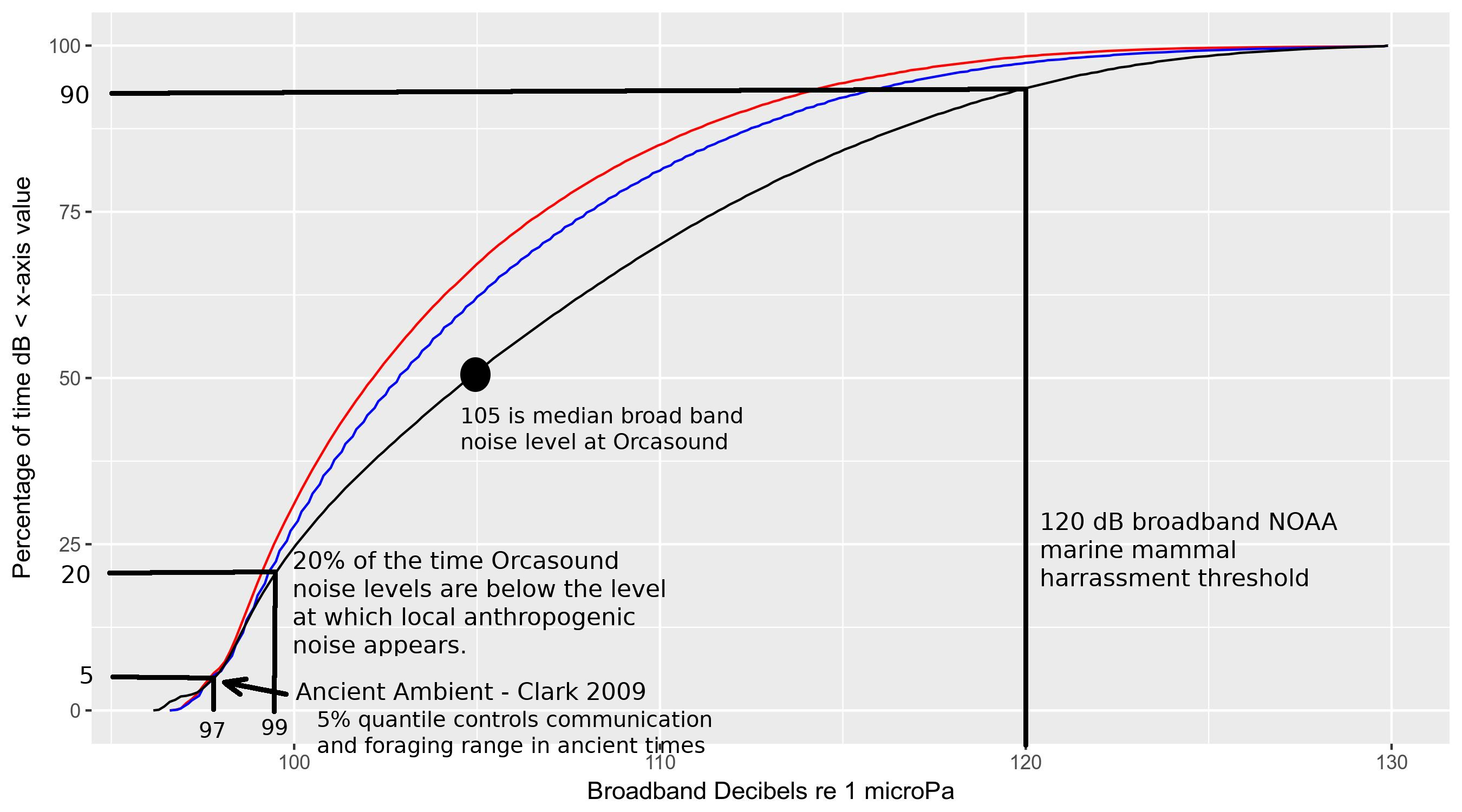
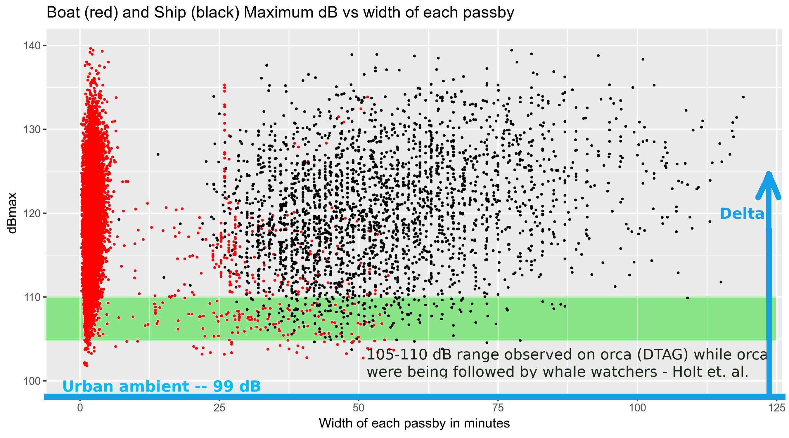
We know that smaller vessels like recreational powerboats aren’t required to carry AIS-B transponders and are common in SRKW killer whale habitat. In the summer months, preliminary studies suggest these vessels raise median broadband sound pressure levels by about 2 dB re 1uPa in Haro Strait. How much does each type of boat contribute to this underwater noise pollution?
To answer these questions we initiated the Orca Eye Aye project in fall, 2022. The aim was to apply new image classification AI to the growing archive of vessel image data from the M2 system at Orcasound Lab. The initial goal was to tune an object detection algorithm to find ships or boats in M2 images from Orcasound Lab. The secondary goal was to automate categorization of each detected object into 11 vessel classes.
Led by Beam Reach “extern” Ze Cui, working remotely from California, the project culminated in early 2024 with the release of version 1 of an open labeled data set, open source code repository, and open vessel detection and classification models (Yolo8). Ze was mentored by Sam King, Scott Veirs, and Val Veirs, with advice and feedback from Virgil Zetterlind, Brendan Tougher, and Bryant Irawan.
Learn more in the Orca-Aye-Eye repository on Github.
Marine Monitor project
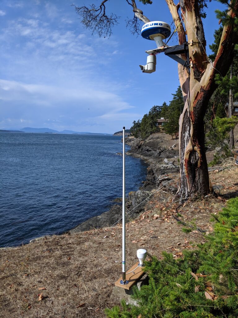
In fall, 2019, the creators of the Marine Monitor (M2) system partnered with the hosts of Orcasound Lab to deploy a tree-based system overlooking central Haro Strait. Brendan Tougher of Protected Seas installed the system which is hosted by Val and Leslie Veirs. Sam King and Virgil Zetterlind monitor and maintain the system remotely and manage the real and archived data streams, with help from Scott Veirs of Beam Reach.
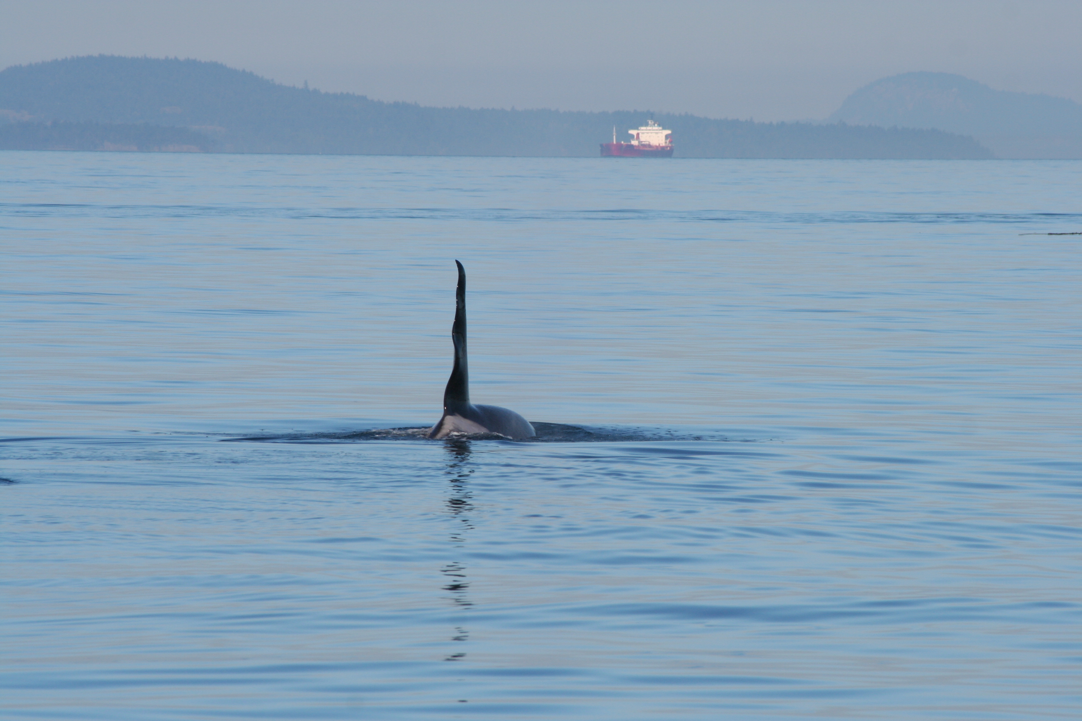
The primary goal of the collaboration is to continue gathering a baseline of vessel traffic in the core summertime critical habitat of the endangered SRKWs, primarily to contextualize the underwater noise data collected at Orcasound Lab. A secondary goal is to beta test and improve the M2 monitoring software during real time noise pollution events and after other marine incidents, like the sinking of the Aleutian Isle fishing vessel in August, 2023, just south of the site.
Sep 2-4, 2019: Initial installation of an M2 system at Orcasound Lab by Brendan and Val
Aug, 2023: Aleutian Isle incident
Sep 3, 2024: 5-year anniversary (including Scott/Val effort to re-level the wooden support platform)
M2 at Orcasound Google photo album (5+ years of photos from the field site)
NEMES camera project
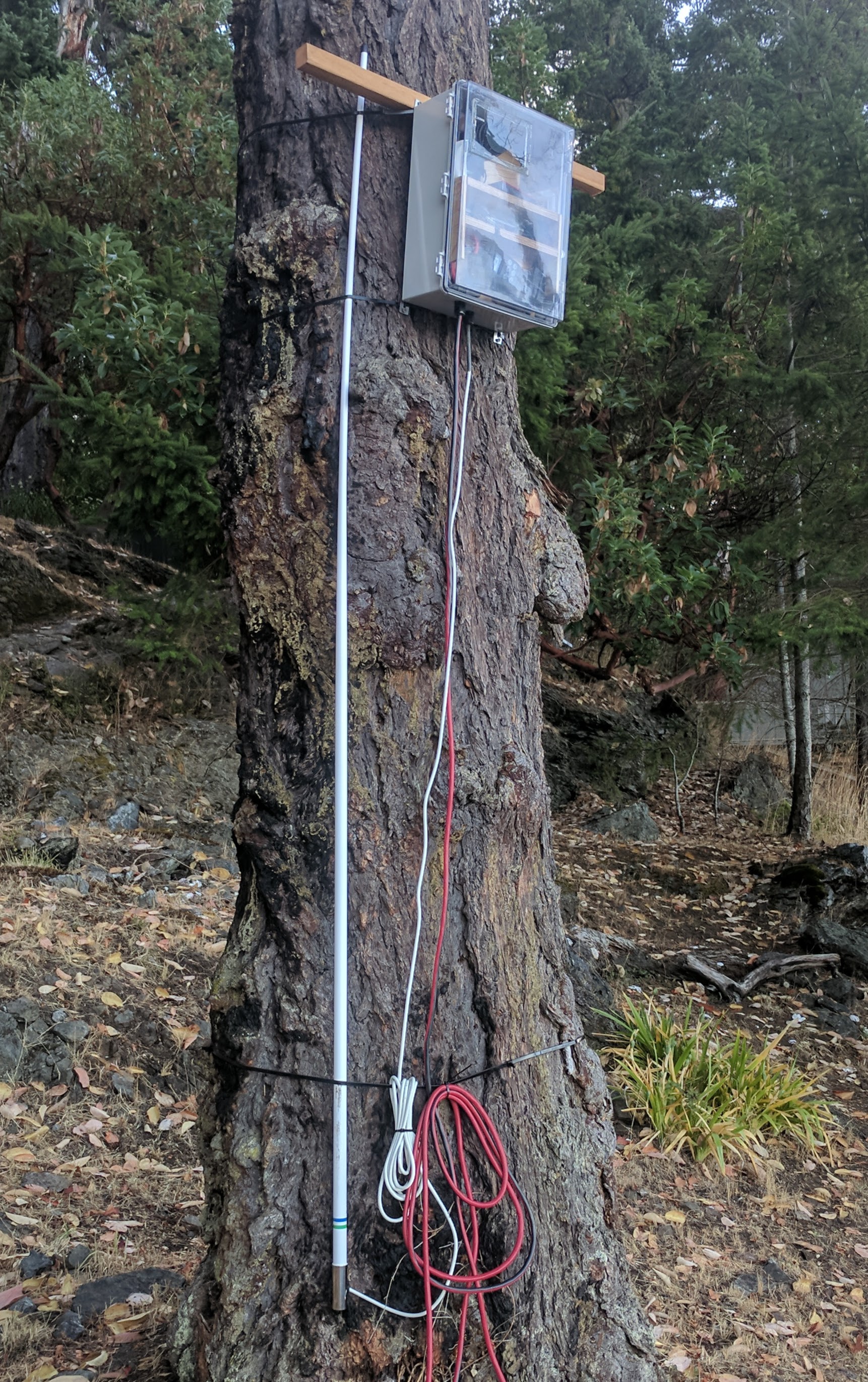
The NEMES project studied Noise Exposure to the Marine Environment from Ships and was led by Dr. Rosaline Conessa of CORAL (Coastal and Oceans Resources Analysis Laboratory). NEMES researchers Dr. Lauren McWhinnie and Patrick O’Hara developed an automated DSL camera system to assess the distribution and behavior of non-AIS boats and to verify the AIS data that is commonly used to track ships. The system was deployed at the Orcasound Lab site on the trunk of a large conifer:
Methods
One of the NEMES camera systems was deployed in August, 2017, at the Orcasound Lab hydrophone node where both calibrated underwater sound pressure levels and AIS data are logged continuously within the summertime habitat of the SRKWs (along the west side of San Juan Island, WA, USA). Strapped to a tree with a view of Haro Strait, the camera captures both the commercial ship traffic going to and from the Port of Vancouver and other ports of the northern Salish Sea, a wide variety of other ships, and boat traffic associated with the nearby ports of Roche and Snug Harbors. Photos are taken during the daytime on a duty cycle designed to allow the speed of boats to be computed (by taking a few images separated by a second or two, and then waiting for ~10 seconds before repeating the cycle).
Visual data analysis has been focused on deriving algorithms for automatic detection and tracking of vessels in the camera images. Val Veirs of Beam Reach has also written and tested software that allows a vessel in the image to be located geographically on the sea surface (e.g. relative to our hydrophone location) by making measurements within the image. Here’s an example of how the acoustic and visual data can be combined:
Results
More than 2.5 million images have been acquired with the NEMES camera at Orcasound (as of fall, 2018). This time lapse video presents an example of NEMES images, in this case from all daytime hours on 9/27/17 — a day when the southern resident killer whales traveled through our study area, along with a wide variety of boats and ships.
Invited presentation at the 2018 Acoustical Society of America meeting
Orcasound lab: A soundscape analysis case study in killer whale habitat with implications for coastal ocean observatories
- ASA web page for the talk, including the abstract
- Slides from the presentation (online, HTML5-based deck)
- Github repository for the talk (all figures in content directory)
- Key (final) figures from the talk:
I am very interested in volunteering on this project in the location of the San Juan Islands. I’m available anytime and would like to discuss this opportunity further with you.
Thanks,
Jeanie Johnson
360 303 5477
jjwildwoman@hotmail.com
Hi Jeanie, please join us on our chat tool, Zulip, to learn more about volunteer opportunities.